|
|
 |
|
|
LOCATION
"Mambucal"- a term that refers to the "boiling" sulfuric mud and
hot springs found in abundance in the area, is located about 31-km. from the capital city of Bacolod, in
the north-western foot of majestic Mt. Canlaon volcano, and highly accessible by land transport about an hour's drive passing
thru the Municipality of Murcia of which it is geographically a part of.
Known to exist as early as during Spanish times in the Province, Mambucal was developed
to become the "resort" of the local social elite who sought refuge from the summer heat in the lowlands at the turn-of-the-century,
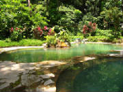
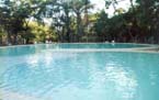
this 25-hectare area of what is now one of the major jump-off points for a Canlaon ascent, MAMBUCAL
MOUNTAIN RESORT is now the premiere mountain resort owned and managed bly the Provincial government of Occidental
Negros, complete with facilities from Hotel and restaurant, swimming pools, to a 300-pax capacity Convention Hall, and other
amenities as well.
|
|
|
|
|
| |
SCENIC MAMBUCAL - GUINTUBDAN
TRAIL SYSTEM
|
|
|
|
Arrive Bacolod City / proceed by land transport for Mambucal Mountain Resort /
Rest of the day is FREE for you to explore the sights and attractions around the resort
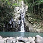
or hike your way up to the "7th Falls" (of which the Resort is famous for), or go swimming.
DINNER will be served at the Hotel's restaurant/
Overnight stay at the Hotel..
|

|
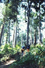
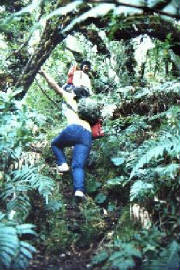
| Several climbing enthusiasts begin the trek from Mambucal each summertime |
|
|
DAY - 2
|
Early morning breakfast
Trekking starts from the Resort bound for the forest line. Portions of the trail in this section are practically
open and must be negotiated long before the sun gets higher in the sky.
The trek within the forested area will continue for the rest of the day until arrival at the so-called "Hardin
Sang Balo" (the widow's garden) in the late afternoon where Camp will be set up for overnight stay.
DINNER by campfire (weather permitting).
|
|
|
DAY - 3
|
Early morning breakfast at the Camp/
Break camp and proceed with the trek along winding trails that pass thru "Elfin forests" and "Dwarf trees"
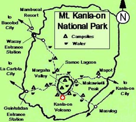
and rain-fed lagoons until reaching the area of the "Margaha Valley" (large extinct crater) near the summit
area around noontime.
The "Valley" is actually a large extinct crater measuring about a kilometer across and some 450-feet below
the ridge line, where the valley floor is a large 2-hectare flat (like a football field) where rainwater accumulates to form
a large lagoon during the rainy season.
Depending on weather situation, the group may OPT to take the summit- or proceed down to the valley floor to
establish Camp, or establish Camp right on the ridge (locally referred to as the "shoulder").
DINNER by campfire.
|
|
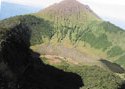
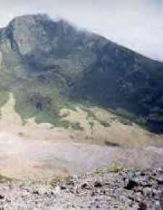
| Margaha Valley with the summit-crater as viewed from Makawiwili Peak |
|
|
DAY - 4
|
Early morning breakfast at Camp
Break camp and begin ascent to the summit-crater early to catch the sunrise. Take a breath-taking
view of the inside of the active crater which is about 300-m across and dropping directly down the cylindrical shaped crater
to a depth of some 800 feet, where stream of sulfur smoke and vapor gushes out of cracks and crevices on the crater floor.
After a few moments of triumph at the summit, the group will begin the 5-hour (average) descent down to
the village of Guintubdan on the western side of the mountain.
DINNER will be at the village where the local chieftain will confer the Certificate for having climbed the
"sacred volcano" of sugar island.
Overnight at Guintubdan village.
|

|
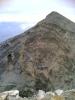
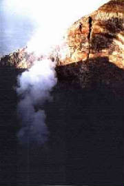
| Mild eruption of Mt. Canlaon occurred during the climbing season of 1996 |
|
|
DAY - 5
|
Early morning breakfast
Depart Guintubdan after breakfast for Bacolod City (via La Carlota City)
END OF CANLAON CLIMB PROGRAM
|
.
|
| |
GUINTUBDAN TRAIL PROGRAM-ITINERARY
|
|
|
|
Arrive Bacolod City / proceed by land transport for BuenosAires Mountain Resort in
the City of Bago, about an hour's drive southeast of Bacolod City/
Rest of the day is FREE for you to explore the sights and attractions around the resort
or go swimming.
Depart Buenos Aires for the village of Guintubdan late in the afternoon and check-in at
the Rafael Salas Nature Park & Convention Resort at the foot of the volcano/
DINNER will be served at the Resort's restaurant/
Overnight stay at the Convention Hotel..
|
|
| Several climbing enthusiasts begin the trek from Mambucal each summertime |
|
|
DAY - 2
|
Early morning breakfast at the Convention Hotel.
Trekking starts from the Resort bound for the forest line.
LUNCH will be served at a rest stop along the trail.
The trek within the forested area will continue for the rest of the day until arrival at the "shoulder"
or specifically (part of) the rim of a large extinct crater just below the active cone of the summit-crater in the late afternoon where Camp will be set up for overnight stay.
(Depending on the weather, the group may OPT to go down to the valley floor for the overnight camp).
DINNER by campfire (weather permitting).
|
|
|
DAY - 3
|
Early morning breakfast at the Camp/
Break camp and proceed with the final trek for the ascent to the summit-crater of this 2,465-m high
peak along the ridge with its "Elfin forests" and "Dwarf trees"
before coming out into an open area at the base of the active crater dominated by alpine-type of grass,
but otherwise barren and rocky.
After a few moments of triumph at the summit, the group will begin the 5-hour (average) descent down back to
the village of Guintubdan on the western side of the mountain.
DINNER will be at the village where the local chieftain will confer the Certificate for having climbed the
"sacred volcano" of sugar island.
Overnight at Guintubdan village.
|
|
| Margaha Valley with Makawiwili Peak as seen from the summit crater |
|
|
DAY - 4
|
Early morning breakfast
Depart Guintubdan after breakfast for Bacolod City (via La Carlota City)
END OF CANLAON CLIMB PROGRAM
|
|
| Mild eruption of Mt. Canlaon occurred during the climbing season of 1996 |
|
|
|
|
|
|
Copyright(c)2006 TravelKonsult & Tours Services-Philippines
|
|
|
|